10 Best Gps Chartplotters 2025 in the United States


Related Products
Up to 15% off
![Garmin ECHOMAP UHD2 54CV Chartplotter/Fishfinder with US Coastal Maps and GT20-TM [010-02591-51]](https://images-proxy.bestreviews.guide/f16PPKwYnNR-RMlbPqY8zwpD3wg=/0x300/https://m.media-amazon.com/images/I/41BRHsBRy+L._AC_CX679_.jpg)
Our technology thoroughly searches through the online shopping world, reviewing hundreds of sites. We then process and analyze this information, updating in real-time to bring you the latest top-rated products. This way, you always get the best and most current options available.
Our Top Picks
Winner
Garmin ECHOMAP UHD2 94sv with GT56 Transducer, 9" Touchscreen Chartplotter, Garmin Navionics+ U.S. Coastal
Most important from
147 reviews
The Garmin ECHOMAP UHD2 94sv is an impressive chartplotter designed for boaters and anglers looking for reliability and advanced features. With its 9-inch touchscreen display, users can expect easy navigation with bright, clear visuals that remain readable even in sunlight. The included GT56-TM transducer provides traditional sonar along with ClearVü and SideVü scanning, ensuring detailed underwater views, which can greatly enhance fishing efficiency. Plus, the built-in Garmin Navionics+ charts cover U.S. coastal areas, offering comprehensive navigation options right out of the box.
One of the standout features is the built-in Wi-Fi connectivity, which allows users to wirelessly share data with another compatible ECHOMAP UHD2, making it easy to coordinate between multiple devices. This chartplotter also connects to the Garmin Force trolling motor, enabling users to create routes and control motor functions directly from the chartplotter interface.
There are a few considerations to keep in mind. While the touchscreen is responsive and user-friendly, some users might prefer physical buttons, especially in rough waters or when wearing gloves. The resolution at 1024 x 600 is decent, but some competitors offer higher resolutions, which could provide even sharper images. Additionally, while it’s a versatile device, users entirely new to chartplotters may find the initial setup slightly complex, though the included documentation helps ease that process.
Most important from
147 reviews
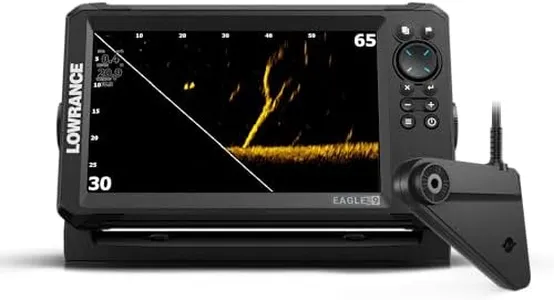
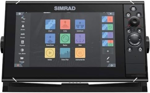
Lowrance Eagle Eye™ 9 Live AMER, 9" IPS Screen, Eagle Eye™ transducer, C-MAP® Inland Charts for The US, with Coverage of Over 17,000+ American Lakes
Most important from
51 reviews
The Lowrance Eagle Eye 9” Live Sonar is designed for anglers and boaters who want reliable navigation and fish-finding capabilities without the complexity that some other models offer. One of its standout features is the four sonar views it provides, such as Live Forward and DownScan Imaging, allowing for clear images of underwater environments and increased chances of spotting fish. The unit comes with detailed C-MAP charts, which enhance navigation on US inland waters, making it an excellent choice for recreational fishing and boating enthusiasts.
The 9-inch LED display is another strength, boasting an IPS technology that ensures visibility from all angles, even when using polarized sunglasses. This makes it practical for outdoor use. The product also features a new twist-lock connector, which simplifies installation on various boats or kayaks—a great advantage for users who may not be tech-savvy or experienced in electronics.
The reliance on a battery power source means users must monitor battery levels closely, especially on longer trips where charging options may be limited. Additionally, the product is relatively new to the market, so its long-term reliability and performance over time remain to be seen. In terms of connectivity, it could benefit from more advanced options like wireless connectivity for data sharing, which might be a consideration for users looking for integrated tech solutions. Lastly, though the touchscreen is user-friendly, some individuals may still prefer button controls, especially in wet conditions.
Most important from
51 reviews
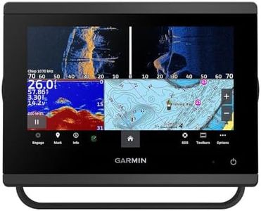
Garmin 010-02366-61 GPSMAP 943xsv SideVü, ClearVü and Traditional Chirp Sonar with Mapping - 9", Navionics+
Most important from
14 reviews
The Garmin 010-02366-61 GPSMAP 943xsv is a robust GPS chartplotter that comes with a 9-inch IPS display, which offers clear and improved display optics for easy readability in various lighting conditions. The screen size is quite generous, making it easy to view maps and sonar details without straining your eyes. This model supports SideVü, ClearVü, and traditional Chirp sonar, providing ultra high-definition scanning to give a detailed view beneath your boat, which is excellent for fishing and navigation.
Another notable feature is its Panoptix sonar support, which allows real-time scanning of the surroundings, adding to the comprehensive sonar capabilities of this device. Pre-loaded mapping, including Navionics+, is a significant advantage as it ensures that you have access to detailed and up-to-date charts right out of the box. The GPS receiver is reliable, enhancing navigation accuracy, which is crucial for safety on the water. Connectivity features enable integration with other marine electronics, which can be a big plus for those with more complex setups.
Some users might find the weight (8.48 pounds) and size (16.3 x 8.9 x 12.4 inches) somewhat bulky, particularly if space is limited on their vessel. The Garmin GPSMAP 943xsv seems well-suited for those who require detailed sonar imaging and reliable mapping for marine navigation and fishing.
Most important from
14 reviews
Buying Guide for the Best Gps Chartplotters
Choosing the right GPS chartplotter can significantly enhance your navigation experience, whether you're a seasoned sailor or a weekend boater. A GPS chartplotter combines GPS navigation with electronic charts, providing you with real-time positioning and detailed maps. To make an informed decision, it's essential to understand the key specifications and how they align with your specific needs. Here are the main specs to consider when selecting a GPS chartplotter.FAQ
Most Popular Categories Right Now


