10 Best Marine Gps Chartplotters 2025 in the United States


Related Products
Up to 15% off
![Garmin ECHOMAP UHD2 54CV Chartplotter/Fishfinder with US Coastal Maps and GT20-TM [010-02591-51]](https://images-proxy.bestreviews.guide/f16PPKwYnNR-RMlbPqY8zwpD3wg=/0x300/https://m.media-amazon.com/images/I/41BRHsBRy+L._AC_CX679_.jpg)
Recommended lists

Gps Chartplotters
Our technology thoroughly searches through the online shopping world, reviewing hundreds of sites. We then process and analyze this information, updating in real-time to bring you the latest top-rated products. This way, you always get the best and most current options available.
Our Top Picks
Winner
Garmin ECHOMAP UHD2 94sv with GT56 Transducer, 9" Touchscreen Chartplotter, Garmin Navionics+ U.S. Coastal
Most important from
147 reviews
The Garmin ECHOMAP UHD2 94sv is a 9-inch touchscreen chartplotter that stands out for its bright, sunlight-readable display, making it easy to view even in direct sunlight. It has a resolution of 1024 x 600, which provides clear and detailed images. The device is equipped with the GT56 transducer for traditional, ClearVü, and SideVü scanning sonars, enhancing its capabilities for detailed underwater imaging – a great feature for fishing enthusiasts. It comes preloaded with Garmin Navionics+ U.S. Coastal charts, offering comprehensive mapping options for coastal navigation. GPS accuracy is reliable, which is crucial for marine navigation, ensuring you stay on course accurately.
The built-in Wi-Fi connectivity allows for seamless sharing of sonar data, waypoints, and routes with another ECHOMAP UHD2 chartplotter, which is handy for those using multiple devices on their boat. Additionally, it can wirelessly connect to a Force trolling motor to follow routes, navigate to waypoints, and control speed, adding convenience for anglers. The user interface is intuitive and user-friendly, thanks to the touchscreen feature, making it easy for both beginners and experienced boaters to operate. The device is designed for durability and has a good waterproof rating, suitable for harsh marine environments.
However, at 8.08 pounds, it is relatively heavy, which might be a consideration for those looking for a more portable option. Despite its robust feature set, it might be on the pricier side, but the value it offers in terms of advanced sonar technology and connectivity could justify the investment for serious boaters and fishers.
Most important from
147 reviews
Garmin 010-02366-61 GPSMAP 943xsv SideVü, ClearVü and Traditional Chirp Sonar with Mapping - 9", Navionics+
Most important from
14 reviews
The Garmin 010-02366-61 GPSMAP 943xsv is a versatile marine GPS chartplotter that stands out in several key aspects. Featuring a 9-inch IPS display, it offers clear and vibrant visuals, which are crucial for easy viewing under different lighting conditions on the water. The ultra high-definition scanning sonar, including SideVü, ClearVü, and traditional Chirp Sonar, provides detailed underwater images, making it easier to identify structures and fish. It also supports Panoptix sonar, adding to its advanced fish-finding capabilities.
Pre-loaded mapping simplifies navigation, and the inclusion of Navionics+ offers additional chart options, enhancing your ability to navigate coastal and inland waters accurately. The GPS accuracy is top-tier, ensuring that you get precise location data, which is essential for safe and effective navigation. Connectivity options are robust, allowing for integration with other marine electronics and smart devices. The user interface is designed to be intuitive, making it easier for both beginners and experienced boaters to operate.
Durability and waterproof rating are also noteworthy, ensuring that the device can withstand harsh marine environments. However, on the downside, the 9-inch screen might feel a bit small for those who prefer larger displays for detailed charting and sonar readings. Additionally, while it offers a comprehensive feature set, the price point might be on the higher side for budget-conscious users. This GPS chartplotter is well-suited for serious anglers and boaters looking for a reliable and feature-rich marine device.
Most important from
14 reviews
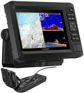
Garmin ECHOMAP UHD2 74cv with GT20 Transducer
Most important from
19 reviews
The Garmin ECHOMAP UHD2 74cv with GT20 Transducer is a solid choice for boating and fishing enthusiasts. It features a 7-inch screen, which is a good size for easy readability while out on the water. The display's resolution and clarity are typically strong points for Garmin devices, making it easier to view maps and chart data. The unit includes detailed US Coastal maps, which are beneficial for navigation and fishing in coastal areas. GPS accuracy is reliable, ensuring precise location tracking. Additionally, the GT20-TM Transducer enhances the unit's capabilities with sonar features, which is highly useful for fishing.
Connectivity options are robust, allowing for integration with other devices and network systems on your boat. Users will likely appreciate the intuitive interface that Garmin is known for, which makes it easier to operate even in challenging conditions. In terms of durability, the ECHOMAP UHD2 74cv is built to withstand marine environments, including a solid waterproof rating, ensuring it can handle exposure to water and rough conditions.
There are a few potential drawbacks. The 7-inch screen, while sufficient, may be considered small for those who prefer larger displays for more detailed viewing. The product's price point might be on the higher side compared to other units with similar features. This chartplotter is best suited for serious boaters and anglers who need a reliable, feature-rich device for navigation and fish finding.
Most important from
19 reviews
Buying Guide for the Best Marine Gps Chartplotters
Choosing the right marine GPS chartplotter can significantly enhance your boating experience by providing accurate navigation, detailed maps, and essential information about your surroundings. To make an informed decision, it's important to understand the key specifications and how they align with your specific needs. Here are the main factors to consider when selecting a marine GPS chartplotter.FAQ
Most Popular Categories Right Now


